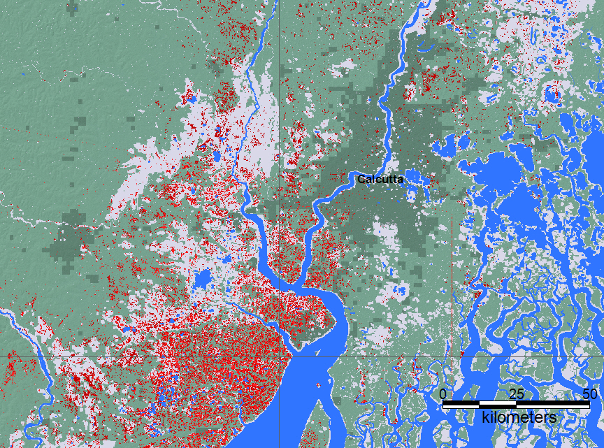
India and Bangladesh – Torrential Rain From Cyclone Amphan Triggered Flooding 21 May, 2020. Storm surge and torrential rain brought by Cyclone Amphan caused flooding in parts of West Bengal in India and Bangladesh. Amphan made landfall in eastern India on 20 May, with winds of 185 km/h causing damage in the state of Odisha and in particular in West Bengal in India before moving on to Bangladesh. Thousands of homes have been damaged or destroyed. Winds ripped off roofs and downed trees and power lines. Millions across India and Bangladesh have been left without electricity. West Bengal Chief Minister Mamata Banerjee said at least 12 people had died in the state. The Chief Minister said the districts of South and North 24 Parganas and East Midnapore were the worst affected. At least 9 people are thought to have died in Bangladesh with fatalities reported in the districts of Jashore, Bhola, Barguna, Patuakhali and Pirojpur. More than 650,000 people had preemptively evacuated their homes in West Bengal and Odisha states in India. As many as 2.4 million people had moved to safe shelters in Bangladesh. Amphan dumped more than 250 mm of rain in 24 hours in Kolkata, flooding the city’s streets. Images on Social Media showed flood water up to car windows. Kolkata Airport was also flooded and flights temporarily suspended. Heavy rain was also reported in parts of Bangladesh. Ishwardi in the west of the country recorded over 155mm of rain in 24 hours to 21 May. Storm surge of 1.5 metres was reported along parts of the country’s low-lying coast. An embankment in Bagerhat District in Khulna Division collapsed, flooding nearby villages.
Modelling
Commencing May 19, 2020, India and Bangladesh experienced excess rainfall and flooding from Tropical Storm Amphan. These early results are from the NASA-supported Global Flood Monitoring System (GFMS) at ESSIC, University of Maryland. Date and UTC time is shown. This is flooding as modeled from input precipitation data.
Maximum Observed Flooding
Red is all mapped flooding from this event. Blue is a reference normal water extent. Light gray is all previously mapped flooding, since 1999. See also the DFO Web Map Server. Over the course of the event, remote sensing data are combined to show all flooded areas. Click on colored dots for access to River Watch results. Last update of this map: Displayed flooding for this event is within the range: May 21-22, 2020.

Login to comment.

Customer reviews